


Boullard et les hameaux abandonnés (La Javie 04)

Clo0413
User
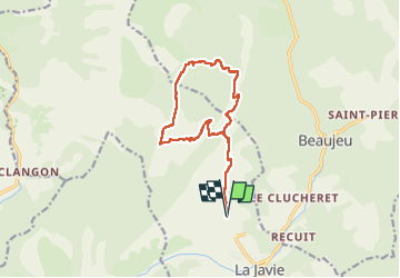

Length
14.2 km

Max alt
1334 m

Uphill gradient
608 m
Km-Effort
22 km

Min alt
814 m

Downhill gradient
607 m
Boucle
Yes
Creation date :
2024-12-09 08:33:08.332
Updated on :
2024-12-09 18:44:49.643
4h17
Difficulty : Easy

FREE GPS app for hiking
 SityTrail
IGN / Geographical institutes
SityTrail Plus
The world is yours!
About
Trail Walking of 14.2 km to be discovered at Provence-Alpes-Côte d'Azur, Alpes-de-Haute-Provence, La Javie. This trail is proposed by Clo0413.
Positioning
Country:
France
Region :
Provence-Alpes-Côte d'Azur
Department/Province :
Alpes-de-Haute-Provence
Municipality :
La Javie
Location:
Unknown
Start:(Dec)
Start:(UTM)
287481 ; 4895970 (32T) N.
Comments